Replies: 22 comments 30 replies
-
|
A lot of driver are alone in the car. Around your living place I think it is not hard for you to add the correct speed limit manually in OSM. you can use the Max speed overpass to check your neighborhood. |
Beta Was this translation helpful? Give feedback.
-
Sure, I was mainly thinking about highways and such roads, not commuting travels :) |
Beta Was this translation helpful? Give feedback.
-
|
You can use OSM Notes to mark changing speed limits(as passenger). After your trip you can open OSM in your browser and fix speed limits with the online editor. Also there are country specific maxspeed in city or outside. In Austria for example are 50km/h in city, 100km/h outside the city and 130km/h on motorway. |
Beta Was this translation helpful? Give feedback.
-
|
Editing Speed Limits during driving is quite hard. In most cases the road Segment Needs to be cuted where the Limit starts and where it ends. |
Beta Was this translation helpful? Give feedback.
-
I agree. Either take photos or add an OSM note where the speed limit is missing or wrong so that others can fix or resurvey it. |
Beta Was this translation helpful? Give feedback.
-
|
Yes there are no nice widgets to use. Though you can use Quick Action button and create templates for several actions like creating quickly poi/notes and then later submit it to OSM. |
Beta Was this translation helpful? Give feedback.
-
|
What about reading from GPX files? Otherwise, I would suggest taking photos for Mapillary. |
Beta Was this translation helpful? Give feedback.
-
|
I, too, thought of determining cruise speed from recorded tracks. Though, would still need a survey to accurately place the positions of speed zone boundaries. |
Beta Was this translation helpful? Give feedback.
-
Sure, but they could be coded in OSM as well, isn't it? By the way, for France at least, default speed limits are tagged
Sure, that's one of the main obstacle I see in editing speed limits (that's also an issue I'm aware of with StreetComplete). Not sure if this could be easily automated?
Mapillary is not the easier solution in my opinion. Is there a plugin to take pictures from Osmand (I'm not aware of this)? Else, it means switching between two apps (and then, driver can no longer see upcomings instructions). Additionnally, Mapillary app is not opensource and I know some users can't use it (not available on F-Droid for instance).
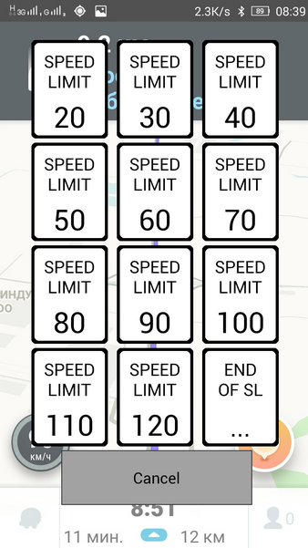
Actually, given the previous comments and the specifities of OSM speed limits, this sounds like a really nice UI. I can think of having a speed limit display, with a "?" sign instead (for instance) if the speed limit is unknown. Clicking on it would open a popup to enter speed limit (an input field of type number, or maybe something like this with predefined speed limits https://vinkoy.github.io/wslb/images/site_338_043/img2.png?) and this would result in a note added into OSM according to a predefined template. What do you think about it? Having a set of predefined speed limits means user could tweak it according to their local legislation (then solving issue of speed limits differing from one country to another). Adding a note means there is no special OSM edition to handle. The only remaining issue I could think of is handling the end of speed limit, but I guess this could be handled by clicking again the speed limit button and adding a templated "end of previous speed limit" OSM note? |
Beta Was this translation helpful? Give feedback.
-
|
@Lee-Carre thank you for sharing your thought in detail. I'm just wondering how you would know the attitudes of @Phyks well enough to criticise him on a personal level. Let's better stay with the topic, ok? @Lee-Carre I love your engagement for contributing to osm and I guess it adds a lot of value. But think about others that might not be able or do not want to be involved this deep. Or just don't know enough about it or are not enough used to technologies. E.g. my mother could click a button to add a speed limit, but she could not maintain a setup like you described (and would also probably not see the value of it). |
Beta Was this translation helpful? Give feedback.
-
|
I probably shouldn't reply to this as it doesn't need more airtime. But here goes anyway. @NotSoImportant it is not easy to contribute speed limits in StreetComplete which is why it's disabled by default. Yes, it's got a simple interface to do it but it requires careful surveying, not what can be achieved while driving. If your mum (or anyone else) doesn't realise that, it's best they aren't editing OSM directly. A note/fixme is as far as it should go. |
Beta Was this translation helpful? Give feedback.
-
|
Hi @tommycrock yes I am aware its not easy. We are looping back to #11409 (comment) I fear this whole idea discussion became too long and ambigous to have a chance ending up in OsmAnd in any form. 😞 |
Beta Was this translation helpful? Give feedback.
-
|
tommycrock summarises more succinctly than I could.
I don't think you are; else you would keep pushing the matter out of what seems to be mere hope. It's inherently non-easy, by nature. No amount of changes to OsmAnd will change that. Others have already mentioned suitable tools for surveying
This misses the point, entirely. Check your assumptions. The problem is that the request is ambiguous (and fraught with complications which likely mean the submitted data won't be of quality). Where's the detailed proposal I suggested be authored (unless it's below, which I'll get to next)? Point is, many concur that this isn't an obviously good fit for an app which is primarily concerned with map-reading & navigation. If you want a surveying editor, there are several (and you know where to find them). I'll paraphrase a French aircraft designer (whose name I forget); “perfection is attained not when there is nothing more to add, but when there is nothing more to remove”.
There's no need to be patronising. I was responding based on what he chose to publish. Relevant context. In fact, that whole section would be informative. If people aren't interested in why this isn't a good idea, and why pushing it is futile, then there's nothing more to be said. Consensus has been reached. When others are trying to help you, maybe don't bite the hand which feeds you.
How condescending. How do you know that I'm not doing as you suggest? How about you address my points instead of my tone (which you clearly dislike)? I'm plenty familiar with the likes of UX design. Plus, I and others have already stated that non-trivial editing isn't a drive-by activity (even when using a proper editor). I don't expect others to do things as I would. However, back to my point (in a different reply) about entry-exams. My point was to give a little insight into why If folks aren't willing or able to do the minimum necessary to have a chance of making a good contribution, then maybe they shouldn't try to contribute. Lowering the bar, by lowering the standards, won't lead to a good outcome (misleading map data, which is bad for everyone, and requires lots of cleanup). Would you complain that the requirements in order to fly a plane, or operate a nuclear reactor, are also unreasonably high, or would you consider them to be there for good reason? I say this as someone who is quite happy to resolve notes left by anonymous users. Even when that involves a several hour survey. I'm pleased that they do, because it informs of where problems are, for someone willing & able to work on. That's exactly why notes may be left without an account. Editing map is inherently much more involved than using one. An author / designer / implementor has to know more than a reader / user. Compare kitchen design. The dishwasher goes next to the sink. Very little question about that. But, the designer doesn't mention this to the customer. He lets them change their mind about the colour of the tiles 50 times, instead. The designer has experience which the future-users don't. If folks want to learn what's involved in kitchen design, then they're welcome to. But, if they're not willing, then the details aren't for them. They'll end up making a mess of it, and being unhappy with the result. Your argument is essentially that the full details should be exposed to all. Well, they'll likely end up with something other than a functioning kitchen. That's why they hired a designer in the first place. I've seen this same pattern play out, plenty. Yes, it would be nice to educate everyone about everything, but that requires a lot of time. Plus, many people just want to read the time, without caring how the clock works (but, then, they can't complain about having less-than-perfect timekeeping, not that to keep precise time requires learning some horology). I am very much a fan of cinéma, but I have zero interest in making any. That's for the writers, director, and production team to figure out. Thus, like I've said elsewhere; if something being corrected in OSM is so important to whoever, then they'll learn the necessary to fix it. Else, hire someone, or leave a note for the enthusiasts. Otherwise, it's not that vital for them. Consider that badly edited map data has real-world effects. Routing, as a prime example. Else generally misleading people. A recent example, by an experienced mapper, in my area, was (undoing a whole bunch of my careful surveying) essentially setting highway=pedestrian & motor_vehicle=designated on several related ways, which were actually closed to motor traffic. Emotional arguments aren't gonna sway tech-minded folks, in the end. Part of that is due to experience, on their part. I've suggested ideas to other projects. Some have been rejected. When an explanation (rationale) was given, as to why it wasn't a good fit for that project, it often made sense. I accepted this, and strived to think of ideas which would fit. Maybe the bottom line is that there is no easy (& good) way of achieving the outcome you wish. That's nothing to do with OsmAnd. Liking the idea of something, or wishing for whatever, doesn't mean the reality of it is plausible. Yes, it would be magically wonderful if a tap of a UI button then somehow did the right thing to correct map data. But, that's not realistic. You seem to be considering only the superficial UI, and none of the mechanics of how that would end up as map data. Yet, when this point is addressed, you end up repeating the same request with different phrasing, as if that changes any fundamentals (which it doesn't). I'm reminded of politicians thinking that they can change the duration of daylight by setting laws. Nope; no amount or wording of legislation will change orbital orbital mechanics. Bleating for a magic solution won't make it materialise. Just as any bleating I did about how it would be nice if folks took the time to understand the context in which they're making their request, and that sometimes requests may be impossible to meet, isn't gonna change a damn thing. Hence trying to educate. But, students have to want to learn, instead of ignoring inconvenient responses about reality, and repeating their hopeful wish. |
Beta Was this translation helpful? Give feedback.
-
|
Hi @Lee-Carre,
I wanted to address both, because a community lives by both: valuable and appreciative communication. I personally think the appreciative part is the bases for any valuable communication. (relevant context)
Exactly. Badly edited data is not something we want and should constructively find a solution that avoids it. On the other hand outdated data is as well not what we want and it is already there: Wrong speed limits that are affecting navigation calculation.
I agree that it would be good to start a new proposal. Imho it should be focused around discussing different implementation possibilites. And then comments should be to each of these concrete ideas. |
Beta Was this translation helpful? Give feedback.
-
|
I like the idea of having a simple way to add missing speedlimits. |
Beta Was this translation helpful? Give feedback.
-
OSM is a community, not a corporation with employees to make fixes for users. The few plausible options I can think of are
It's no good thinking about this only from a front-end UX perspective. It also requires thinking about how it would work on the back-end (how do your taps end up changing the map, without you contributing a changeset with a proper editor?). Whining that it should just be trivial doesn't help anyone. There's no ‘customer service’ which you can nag into submission. Waze and similar are closed systems which their proprietors control. So, their employees can do all this for you in the background while you remain blissfully unaware. OSM is radically different (for good reason). If you wanna improve OSM then get an editor (StreetComplete would be an excellent one for newbies) and become a contributor. Don't like this reality? Then OSM may not be for you. As an on-foot surveyor, I know only too well how much effort is involved to make even a handful of worthwhile (non-trivial) changes. Think about how far apart speed-limit signs are (now imagine finding none along a road, because it's within a slow zone, and you have to go hunting for signs on various other roads). So, if you want sympathy then you'd best look in the dictionary (kudos to Terrance Popp). Plus, editing (especially while out) is a whole lot easier now than in the past. In the early days it was a process of taking notes for doing editing back at home. So, mobile editing is the newfangled way. The freedom which OSM affords comes with responsibility. |
Beta Was this translation helpful? Give feedback.
-
|
Hi @Lee-Carre I am an active contributor since years and that is why I propose this improvement. It would make contributing speed limits much easier. Because I like (everybody) to contribute with the best possible interface. Because this will result in more up to date data. Actually this is how I started contributing: I saw some entry beeing wrong and wanted to change it. That is how users are willing to contribute (even if at first they may not even know they are contributing this to osm). Finally: improving the tools will improve osm data in a longer term. |
Beta Was this translation helpful? Give feedback.
-
|
You've not answered any of the relevant questions (about how). Merely restated your desire. That's not productive.
You've voiced an idea / wish / desire / concept. But, not a fully-thought-out specification of exactly what to implement.
But, how would it actually work?(!) See above.
People are different, have different preferences, hence there are many different editors. While user-experience is an important factor, since this isn't a game, it can never be at the cost of the quality of map data. Otherwise, what's the point?
Will it? How? This requires thinking about things from the perspective of real-world users (and not just wishfully or considering only their experience, but if the end result (map data) is any good). What about accuracy of data?
Well, that's also relevant here. OsmAnd needs to know exactly what to change & how. Do cite those discussions here.
LOL, this rather underlines my earlier points; by backend I didn't mean OsmAnd, but OSM. As in, exactly what does OA upload, and to where?
And there's one of the key points; you've yet to demonstrate how this would be a viable improvement. Especially when there are compelling arguments against it being anything of the sort. Like the French aero-designer said; perfection isn't when there's nothing more to add … As you said; other apps allow you to do what you want. Use them. I'd argue that trying to make OA into more of an editor is actually a detriment. That's what actual editors are for, which OA will never match (and I don't want it to, I want it to remain excellent at what it does). Different tools for different jobs. For many very good reasons.
Right, so you were sufficiently motivated to learn how, and then did actually learn. Then you agree with me, and others, when we say that this is no different to what's expected of others.
Very much depends on your definitions. Even so, that's a bold claim, without sufficient evidence. In the end, this is just more wishy-washy wouldn't-it-be-good-if, without addressing practical realities. If you can't answer the questions posed, then at least have the honesty with yourself to recognise that, and refrain from merely repeating wouldn't-it-be-nice-if. Until those questions are answered, this suggestion isn't gonna make any progress. Earlier you complained about the discussion becoming too involved and distracting from your wish. Well, this is exactly that, right here; no amount of talking around the questions will answer them. Until they're answered, no steps forward (if that's even possible, which it seems is not due to the nature of what you seek). |
Beta Was this translation helpful? Give feedback.
-
|
IIRC there is an app to capture speed limits and other map features while driving: |
Beta Was this translation helpful? Give feedback.
-
|
Used it often. Works well. |
Beta Was this translation helpful? Give feedback.
-
This is definitely not the same thing as this issue. OSMAnd has a quite huge user base, extending well beyond the OSM "active" contributors. Most of them are probably willing to contribute at some point (think Waze-like contribution). You will however lose them if they need to install any other app, even more if this is a geeky UX app and definitely loose all of them when they actually have to post-process their edits on a different device / website. :/ |
Beta Was this translation helpful? Give feedback.
-
|
Contributing quality work isn't trivial. [Edited to add:] Some further thoughts:
Yet, the title reads “Contributing speed limits to OSM”. Quite how are they (fundamentally) different? Uploading tracks is contributing to OSM.
Yes, because there are many more people who need a BS-free map & router than there are with enough interest and/or time to contribute. Else, they would choose to become contributors.
What evidence do you base this on? If so, while preserving the necessary prerequisites for contributing quality work, then why don't they contribute? Ah, it's too difficult for them (despite the likes of StreetComplete)? I address this in my next response.
This is fallacious. One can only lose what one already has. This is like claiming that a retailer is losing customers which had never bought anything from said retailer. Quite how is the retailer counting customers, then? Perhaps you mean the opportunity-cost? Well, keep reading.
Consider such prerequisites (to producing quality work) as an entry-exam. Unconditionally increasing the contributor-count isn't a good thing. Consider how many do open an account, and even make a few edits, only to abandon the effort. Why would the results not be worse with a group who didn't even get as far as opening an account. Actually, them having to open an account is no less of a deal-breaker than installing an app. Else, they would've already done it. Even I, a reasonably tech-savvy user, who had been interested in (& using) OSM for years (since early 2010s, if I recall), didn't have an account until less-than-a-year ago (but I added notes). While StreetComplete is a fine app, when I started I was oft irritated by it's (intentional) limitations, because I wanted to correct more than it would allow me to. This prompted me to become proficient with using Vespucci. That desire for quality & taking pride in one's work, makes a difference. Too often (as a surveyor) have I seen sloppy (guess)work which didn't match reality. Incorrect data is worse than that data being absent. Inaccurate data misleads users. The stakes are raised for maxspeed tags; users may inadvertently end up speeding (or going too slowly, which is also hazardous). Ah, but they shouldn't rely on OSM data, and should look for road signs? Well, then what's the point of tagging Worse; what about non-trivial situations, such as conditional-limit zones (e.g. outside schools; where I am, the lower limit only applies when the children are arriving or leaving, during specific time-spans on weekdays); properly tagging those requires a survey and a capable editor. Like others have suggested; for those unwilling to do what it takes to become a contributor, there are always OSM notes for those who are willing contributors (& know how to apply the changes in a sound way) to act on. Otherwise, missing maxspeed doesn't bother most users enough to make the effort to fix the data. |
Beta Was this translation helpful? Give feedback.
-
|
I don't think osmand will loose users because they don't provide a way to edit maps. In fact i cannot remember having a nav used which allows such an action. I appreciate that you want to contribute to osm but there are far better ways. While driving you really shouldn't try to edit maps. Just use the note taking function and edit it afterwards. The note is stored with your current gps data so its easy to find the place and you can add many more information than just speed limit. |
Beta Was this translation helpful? Give feedback.
-
|
I think you missed my point in my latest comment. OSMAnd will definitely not loose users by not providing a way to edit maps. OpenStreetMap ecosystem in general will definitely loose a very valuable way of getting consumers (in the sense of using the data without even noticing it) to contribute.
This workflow is working for a geek or a tech-savvy user. Not for the average nav system consumer. Basically no one except OpenStreetMap active contributors will ever look into a workflow involving taking a note while driving, looking back at notes afterwards, opening openstreetmap.org (or JOSM or any other app) on a device afterwards, logging in and handling the form-based edition to update max speeds. Correct me if I'm wrong, but I do think of OSMAnd as the perfect "Waze-like" alternative based on FOSS. It is also the nav system of choice for a large number of transportation modes (OSMAnd is definitely a thing for cycling for instance). I see it as a perfect entry point for OSM contribution through a very simple task which is max speed editing. From the user point of view, the info is already displayed on screen, easy to check and easy to fix (if we asbtract the OSM way splitting model which is a backend issue). Plus users definitely have a direct feedback on this and see the interest into fixing these. |
Beta Was this translation helpful? Give feedback.
-
|
Turning OsmAnd into an editor (because where does it stop? Everyone has their favourite tags) will diminish it as an app for viewing & navigating maps. As many have said; there exist a variety of apps for editing, including with a pretty GUI. |
Beta Was this translation helpful? Give feedback.
-
|
Hi Lee-Carre. You can use OsmAnd without editing capabilities but since there are people interested in editing you also can: See #11409 (reply in thread) |
Beta Was this translation helpful? Give feedback.
-
|
I'm aware, but thankyou. Editing is relegated to a plugin, with only the basic & obvious essentials. I've no objection to that level of capability (especially adding notes). While I don't edit within OsmAnd itself, I do like the feature of that plugin which adds the element's URL to the properties list, which facilitates examination & editing in more appropriate apps. My concern is over trying to make OsmAnd into more of an editor than this, which would bloat it. This goes against several very sound tech-design principles (for quality software), which exist for many excellent reasons. If others want a plugin for more editing features (which doesn't come included with OsmAnd) then fine. They're welcome to. There already exists other software for editing. No need to reinvent the wheel. |
Beta Was this translation helpful? Give feedback.
-
A consumer, by definition (passive grazer of what's made available to it by actors with agency), isn't interested in contributing. Besides, people don't consume navigation systems (or data); both still exist afterward. Much like tools; do you consume them or use them? This choice of terminology suggests a corporate & proprietary mindset, which is fundamentally against what OSM is about.
That's a tort. Such individuals self-select to become contributors because they're willing to do what's necessary for it. So; yes, of course. That's self-evidently obvious. What's your point? This suggests a fundamental misunderstanding (or ignorance) of what OSM is. Concerning.
This definitely smacks of a proprietary-thinking mindset. OSM isn't the alternative, that suggests that freedom-restricting schemes like Waze are legitimate. Hardly. Based on various relevant history, OSM (being freedom-respecting & community-driven) is the inevitable future. Even the likes of Facebook, Apple, and others have woken up to this. Whenever I hear a Stockholm syndrome victim of some proprietary exploiter lauding the praises of their chosen captor, I smile & laugh. Quite how will Google direct anyone along a road which it doesn't know exists? Alternative? 🤣 I just enjoy the entertainment of watching it try to remain relevant (or, simply, to adhere to their own motto). Much like with Microsoft over the last decade (hence Github).
If it's so simple, then why all the grumbling about how difficult it is, or that any workflow is not to your liking? I think you're conflating your desire for change with the reality involved in achieving it. More front-end-only thinking.
Oh dear, there's so much wrong with this. Not least of which is your dismissal of way-splitting being a backend problem. Not at all. Where to split a way is very much a key piece of relevant data. It affects where tags are applied. I don't think I'm going to bother to explain further. I feel that it would be wasted. Those who need to understand already do. Those who don't, seem unreceptive. I suggest that you submit a full proposal (including spec) as to how this would work and be implemented, end-to-end (especially the part between app input and map data somehow being updated, with a focus on ensuring accuracy & failure-modes). Short of that (and nothing less), the whole way you're approaching this isn't at all persuasive. |
Beta Was this translation helpful? Give feedback.
-
|
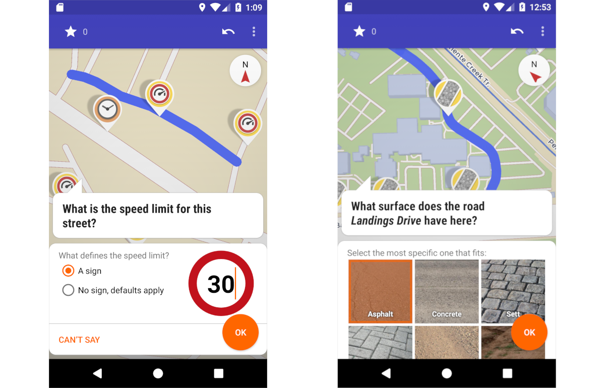
Thanks @Phyks 👍 same thoughts from me. Visual editing is much more intuitive and possible for any "normal" user (compare StreetComplete)
E.g. in TomTom nav you can easily channel back speed limit and other map changes (unfortutately that is vendor locked data), but users complain that feedback does not get incorporated. Related issues/requests for osmand are:
(this is both possible in TomTom) |
Beta Was this translation helpful? Give feedback.
-
It already does: OsmAnd uses OSM data, which anyone is free to edit. What folks here seem to want, is for making a map to be as easy as using it. That's inherently not the case (having done plenty of both, as an on-foot surveyor). Complaining that editing isn't convenient, seemingly without consideration of quality, I feel is like complaining that water is wet or fire is hot. If you want Waze, then you know where to find it. To expect OSM (& related) to be like commercial operations, is to ignore the different models which each is based upon, and the differing incentives. Modularity is a good thing, in so many ways. |
Beta Was this translation helpful? Give feedback.
-
It actually is very convinient with StreetComplete. As for example I am using OsmAnd a lot for car navigation, from time to time I am spotting wrong speed limits. If I could do 2-3 fast clicks to edit, I would do it. But now I end up adding voice memos which because I am lazy, often never actually contribute. |
Beta Was this translation helpful? Give feedback.
-
Yes, I'm familiar, having used it plenty (I'm №1 in my area). SC is convenient for very specific changes, after a whole lot of designing. You've already cited, for example, that SC won't attempt to resurvey maxspeed, along with why. SC only makes tagging changes (I think the only exception is splitting ways, but that serves the tagging ends). There's much that SC can't (and won't) do. Quite a few suggested quests have been rejected as not fitting the criteria for inclusion (which are all set for good reason, after a lot of thinking). As much as I like SC, and recommend it for newbies, I ceased using it (other than as a reference for finding elements in need of attention) because I quickly found it too limiting compared to what I wanted to do. I find Vespucci far more efficient & capable. So, simply parading SC as if it's an anything's-possible solution, misses many points. Again, you're focusing on UI, rather than mechanism. SC already knows what tags to change, on which elements, & how. You've still yet to provide that information for this case. Once again, others have explained how a survey is needed, to determine how a speed zone should be mapped (and I speak as one who has done such surveying). If I recall, SC actually has the maxspeed quest disabled by default. Care to hazard an explanation as to why?
Yes, as you keep repeating. What you wish for has been made clear. What's very unclear is (yet again) HOW exactly that would be accomplished (end-to-end), despite numerous requests. Thus, it's (still) unclear what exactly you're asking for (the details man, don't just keep repeating your desired outcome). If you want the experience of SC then go use it. Trying to have OA become SC makes little sense. Besides, why only for maxspeed (other than it's your favourite tag)? I foresee a slippery-slope.
What you've described isn't a software (or technical) problem, but a human-factors (PEBKAC) one. Non-tech (e.g. social) problems can't be (effectively) solved with tech responses. If you're unwilling to do the work yourself, then leave a note for others. This seems to contradict your earlier statements about being an enthusiastic contributor. You can either have your cake, or you can eat it. Not both. No amount of complaining will change that reality. Even so, you haven't described what those 3 fast clicks should be, or what effect (as in, mechanism) they should have. Given that others have pointed out that you're best off leaving notes, and described ways of doing that. Yet, you persist. In the end, people are just gonna ignore you until you're ready to engage productively (by answering necessary questions). There are viable solutions. If you don't like or want to use them, that's on you. Given the motive for your request, there's little justification for expending the effort to implement it (even if you had described those parts). |
Beta Was this translation helpful? Give feedback.
-
@Lee-Carre please find in my comment #11409 (reply in thread) that I am not bound to any implementation, but want to have a discussion about possibilities. I never said something different. If a solution based on notes is the best approach am very happing with getting this (not only plain notes, where somebody has to type). But even when you said in another thread
you are not technically following up on this. |
Beta Was this translation helpful? Give feedback.
-
|
I have not used waze yet, but there it seems to be possible to also report back a lot of data, including map issues in a visual way. |
Beta Was this translation helpful? Give feedback.
-
|
@Phyks I totally agree with you. But a possible, although not ideal, temporary solution is to write an osm note, and hope that someone will pick it up, or even you, and add it to OSM. |
Beta Was this translation helpful? Give feedback.
-
|
Good that you agree :-) And yes there is an existing non-ideal & indirect solution. And that's why this issue was opened (I guess): Request to implement a better (visual & direct) solution, because it has a great potential! Also see #7655 |
Beta Was this translation helpful? Give feedback.
-
|
Redesigning the ux of osmand may take tons of effort. It's full with features within features, most of them are quite important. I'm not a ux designer, but I began thinking about it, and how to solve at least some of the stuff. |
Beta Was this translation helpful? Give feedback.
-
I have knowledge & experience. See, for example; openstreetmap/iD#8590
Correct, at least to do it non-badly. UX is as demanding as programming. Arguably even more so (failures of code are more obvious, and easier to quantify). Especially so with something as sophisticated as OsmAnd; not only an impressive array of features, but that many are inter-related and can be used in multiple ways (multiple combinations of components, different modes, configuration galore, and the possibility of using different features in parallel (e.g. optionally recording a track, while doing something else)). There's also quite a variety of users; some who know little and only want the basics (what's the quickest route through morning traffic?), yet others who want complex features & granular configuration. That places a high demand on discoverability (rewarding those who explore the feature set, while not penalising those who only want the basics). Determining what the default configuration should be, is far from trivial. There's then the added challenge of doing this all within the constraints of a portable device. Plus, much as with designing / improving anything, a conceptual framework is needed.
The answers to such questions will inform UI & UX decisions. I could go on. I left a list of beginner / intro reading materials in #7655. Given the feature set, I'm impressed that OsmAnd isn't an unusable mess. It could certainly be better, but it could be a whole lot worse, too. In undertaking such work, priority would (should) be given to common (or important, however that might be determined) use-cases. The likes of editing maxspeed would be dead last. I'd be receptive to further discussion in a relevant thread. |
Beta Was this translation helpful? Give feedback.
-
|
@itzikiap Agree that it's off topic here. Thanks. Too many ideas in my head ;-) So let's continue to discuss here if and how to provide an easy and stimulating way to contribute speedlimit changes. |
Beta Was this translation helpful? Give feedback.
-
|
From a technical point of view there is a long list of arguments why StreetComplete unfortutately has not yet implement this. Probably a lot of them also apply here, but maybe other people here have some ideas how to solve it. |
Beta Was this translation helpful? Give feedback.
-
|
I don't think actually editing speed limits in this way would be positive. I think it could be useful, if Osmand couldn't guess the speed limit, to have a range of values that could be tapped which would automatically add a note to the map. Having said which, it would need to be optional and the screen can already be very busy - you wouldn't want it covering the things you need to see to navigate. |
Beta Was this translation helpful? Give feedback.
-
|
Tap to add a note would be good for not logged in users I guess. For logged in users instead the value could be updated. As there anyhow is no auto-upload this would not harm, because you would need to review that change later. |
Beta Was this translation helpful? Give feedback.
-
|
I'm reluctant to indulge the ill-thought-out idea of this whole discussion (adding fuel to the blaze, as it were), however;
Multiple choices while driving increases risk. Besides distraction, also think about unsteady hands due to road bumps. Though, the whole idea of doing anything other than driving, while behind the wheel of a moving car, is bonkers to me (I have some sobering horror stories). Instead (perhaps more fitting with the part about OA trying to guess); the current (GNSS) speed rounded to the nearest 5 [speed-unit set in profile preferences (mph, kph, whatever)]. Thus, if incorrect, user adjusts vehicle speed to the posted speed limit, and merely has to confirm the value to the app. This, of course, is no substitute for proper surveying, but may suffice for auto-filling a drive-by note. |
Beta Was this translation helpful? Give feedback.
-
Erm, no. Wishful thinking. Reveals a lack of insight. Reading a value from keys is (relatively) a whole lot less complicated than trying to edit said value. OA isn't an editor. Editors have to do a whole lot more. For a deeper understanding, I suggest you learn some programming.
So use SC, then.
Read the source code. Oh, don't know how? Learn. What you're asking for, here, is either a programming course, or a lengthy explanation (which probably still wouldn't satisfy where you're trying to push this).
Once again, how? That's the question you keep avoiding. Nothing wrong with authenticated users also leaving notes. Simple & reliable.
Which, given what you said about not contributing from audio notes, would mean that you'd never contribute it anyway. Do make up your mind. |
Beta Was this translation helpful? Give feedback.
-
|
Just as quick reply. When I read this, I'm convinced this Github idea of contributing speed limits is going nowhere, and that's not for lack of developers or implication / will to contribute a PoC as might be implied in many comments.
Very nice attitude here, it's great to see this in OSMAnd community! (not) OSMAnd codebase is very large and no everyone with software development skills can dive in it. The bare minimum you could do (instead of ad hominem attacks) would be to provide a pointer to the relevant part of the code. Then, if they can learn code, they get their answers. Otherwise, they might ask for more details / input or go find some coding tutorial to dive in it. Anyways, you at least get a chance that your comment is helpful. |
Beta Was this translation helpful? Give feedback.
-
|
I think we're losing focus here. The software is called OSMAND: OpenStreetMap Automated Navigation and Directions. Not OSMANDE: OpenStreetMap Automated Navigation and Directions and Editing. Adding an Editing function to the software is significantly more complicated than what it does now, even if it's only to support adding speed limits. There are many what-if cases that must be considered, even for a simple feature such as this. I don't think that it sous be added to the software; the recommendations to use recorded Notes, or photos/videos recorded by OSMAND, or an external application such as Mapillary or KartaView, are the right way to go. Everyone reading this Issue does know that OSMAND can take photos and video within the app, right? A while back I submitted a feature request #8239 to aid in finding roads that are missing maxspeed values, but I think that's as far as OSMAND should go. It excels at providing data from OSM. Let's not take it away from its core strength. |
Beta Was this translation helpful? Give feedback.
-
Yes users could today already add a note, but that is rather inconvinient. Is it even provided for not logged in users? Being able to change a speedlimit (or add a standardized note) at a tap would result in more up to date speedlimits I guess. And even make users get attracted to contribute. |
Beta Was this translation helpful? Give feedback.
-
Yes, OSM notes may be added without an OSM account. |
Beta Was this translation helpful? Give feedback.
-
|
This issue has completely derived, and I doubt there is any slight chance to move forward given the amount of noise and off-topic discussion in this issue. I'm closing it and unsubscribing (EDIT: Actually it got converted to a Github idea, so no need to close anything. I'm no longer actively involved in promoting it), but you can still mention me (@Phyks) if this is on-topic and not a discussion on a personal level or what you think about me. In short:
The point is not to have an all-editing ability in OSMAnd. The point is that OSMAnd is extremely good at providing driving instructions, and I do know people with no idea of what OSM is using it. They would never contribute (for whatever reason that you deem valid or not: time, complexity, full-fetaured editor, etc.) but they'll happily contribute whatever they can from a simple interface related to what they are using OSM for and at the moment they are using it. They would "instant Waze-contribute" through OSMAnd (incorrect max speed, road incidents, traffic), they would never "offline contribute" (editing the map, which you can also do offline in Waze). Then, the scope of this issue is limited to maxspeed (not my preferred tag, not a first step towards much more, just the only intersection between what could be live-edited in OSM and what OSMAnd is mainly used for) since OSM is not fit for realtime events (road incidents). The only arguable extension I could think of would be "editing the destination POI", which is 1/ already doable in OSMAnd and 2/ could be easily deferred to another app such as StreetComplete (it does not have the same constraints of minimum interaction as in-driving editing). |
Beta Was this translation helpful? Give feedback.
-
Hi,
I noticed Osmand is using OSM speed limits and can be configured to show them on screen while navigating. However (at least near my place), there a lots of roads without any street limit set in OSM.
Waze is also doing a similar thing, displaying the speed limit. But contrary to Osmand (as far as I know), when there is no data there is a nice UI to submit new speed limits. This is super useful and could be used to contribute while driving (for the passenger use, of course). As Osmand is quite widely used as a routing app, I guess it could help put speed limits in OSM quite easily.
I know about StreetComplete which is offering a nice UI as well for setting speed limits, although it is not super convenient to use while driving, and would require a switch of apps.
What do you think about it?
Thanks for all the work you are putting in Osmand!
Beta Was this translation helpful? Give feedback.
All reactions